Constantly seeking safer ways to work underground, Rio Tinto trialled the Hovermap mobile LIDAR scanner to map drive deformation at its Argyle Diamond Mine.
Mobile LiDAR was found to be accurate, cost-effective and reduced underground exposure for Rio Tinto personnel.
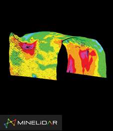
Geotech specialist MineLIDAR was able to scan extraction drives (200m) in 7 minutes with Hovermap vehicle-mounted, significantly reducing the data collection time and exposure risks, especially in areas where heavy vehicles operate.
LiDAR captures a 360° profile of the drive, improving convergence monitoring coverage compared to extensometers.